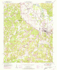
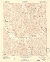
1951 Map of Red Bay
USGS Topo · Published 1973About this map
Red Bay sits at the heart of this landscape along the Mississippi Alabama border, where the Illinois Central railroad cuts through the terrain. The community is a hub of mid-century activity, shown with a landing strip, golf course, and a drive-in theater just outside the town limits. Beyond the developed center, the area is defined by the Freedom Hills and the Valley Divide, which separate the various creek systems including Bear Creek and Chubby Creek.
Find a feature on this map
61 named features on this map. Tap any name to fly to it.
Don’t see what you’re looking for? This feature index may not catch every label — zoom into the map to look around manually.
Map Details
Editions of this 1951 Red Bay Map
3 editions found

Other maps of this area

1935 · Pleasant Site
USGS Topo · 1:24,000

1936 · Belmont
USGS Topo · 1:24,000

1936 · Red Bay
USGS Topo · 1:24,000

1936 · Vina
USGS Topo · 1:24,000

1936 · Halltown
USGS Topo · 1:24,000

1950 · Belmont
USGS Topo · 1:24,000

1950 · Vina
USGS Topo · 1:24,000
1950 · Halltown
USGS Topo · 1:24,000
1950 · Pleasant Site
USGS Topo · 1:24,000
1951 · Pleasant Site
USGS Topo · 1:24,000