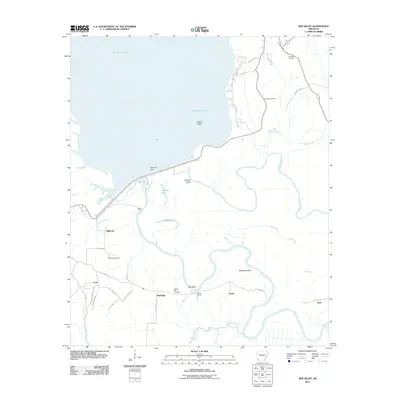
2011 Map of Red Bluff
USGS Topo · Published 2011About this map
Millwood Lake dominates the upper half of this landscape, its expansive waters held back by the Millwood Dam and the long embankment of River Run Rd. This modern hydrologic environment sits atop a network of older landforms and settlements in Little River County. Below the dam, the terrain transitions into a dense web of waterways including Bee Bayou, Hudson Creek, and Bois d'Arc Bayou. The area around the namesake Red Bluff and Shepherd Bluff shows a complex pattern of rural roads like Little River 35 and LR 287 that connect small clusters at Orton, Cole, and Dave. For family historians, the map preserves the locations of several burial grounds, such as Saratoga Cemetery, Hominy Cemetery, and Dowden Cemetery, which reflect the long-standing community footprint in this river-bottom region.
Find a feature on this map
40 named features on this map. Tap any name to fly to it.
Don’t see what you’re looking for? This feature index may not catch every label — zoom into the map to look around manually.
Map Details
Editions of this 2011 Red Bluff Map
This is the sole edition of this map. No revisions or reprints were ever made.
Other maps of this area

1950 · Ashdown East
USGS Topo · 1:24,000

1950 · Ogden
USGS Topo · 1:24,000

1950 · Red Bluff
USGS Topo · 1:24,000

1950 · Ben Lomond
USGS Topo · 1:24,000

1951 · Ben Lomond
USGS Topo · 1:24,000

1951 · Ogden
USGS Topo · 1:24,000

1951 · Red Bluff
USGS Topo · 1:24,000

1951 · Ashdown East
USGS Topo · 1:24,000

1951 · Homan
USGS Topo · 1:24,000

1951 · Mineral Springs South
USGS Topo · 1:24,000