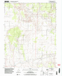
1997 Map of Red Breaks
USGS Topo · Published 2002About this map
Escalante River winds through this arid section of Garfield County, carving a path through a series of high mesas and deep canyons. The landscape is defined by massive sedimentary formations, including the Red Breaks and the expansive Big Spencer Flats. Access to this back-country terrain is limited, primarily marked by the historic Old Sheffield Road and occasional pack trails. The eastern half of the map is largely contained within the Glen Canyon National Recreation Area, where natural landmarks like Natural Arch and The V are prominent. Along the watercourses, scattered Spring labels indicate critical water sources in an otherwise dry environment of high benches like Brigham Tea Bench and Big Bown Bench. The map captures the area as it appeared in the late 1990s, based on earlier imagery that reflects the long-standing isolation of these canyonlands.
Find a feature on this map
18 named features on this map. Tap any name to fly to it.
Don’t see what you’re looking for? This feature index may not catch every label — zoom into the map to look around manually.
Map Details
Editions of this 1997 Red Breaks Map
This is the sole edition of this map. No revisions or reprints were ever made.
Other maps of this area

1886 · Escalante
USGS Topo · 1:250,000

1953 · Circle Cliffs 4 NW
USGS Topo · 1:24,000

1953 · Circle Cliffs 1 SW
USGS Topo · 1:24,000

1953 · Circle Cliffs 4 SW
USGS Topo · 1:24,000

1953 · Moody Creek
USGS Topo · 1:62,500
1953 · Wagon Box Mesa
USGS Topo · 1:62,500

1956 · Escalante
USGS Topo · 1:250,000

1960 · Escalante
USGS Topo · 1:250,000

1964 · Sunset Flat
USGS Topo · 1:24,000

1964 · Tenmile Flat
USGS Topo · 1:24,000