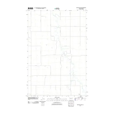
2011 Map of Red Butte NW
USGS Topo · Published 2011About this map
Otter Creek meanders through this portion of Mercer County, defining the drainage patterns and topography of a landscape dominated by the section-line grid of rural North Dakota. The area's settlement history is anchored by the Rhein Cemetery in the southeast, a common marker of the family-based homesteading era in this region. This 2011 survey reveals a vast network of numbered roads, such as 59th Ave SW and 127th St SW, which facilitate access to the agricultural interior between the creek beds and the higher plains. In the southwest corner, the headwaters of Brush Creek emerge, while County Rd 20 provides a primary north-south corridor through the eastern half of the quadrangle.
Find a feature on this map
19 named features on this map. Tap any name to fly to it.
Don’t see what you’re looking for? This feature index may not catch every label — zoom into the map to look around manually.
Map Details
Editions of this 2011 Red Butte NW Map
This is the sole edition of this map. No revisions or reprints were ever made.
Other maps of this area

1954 · McClusky
USGS Topo · 1:250,000

1958 · McClusky
USGS Topo · 1:250,000

1968 · Red Butte
USGS Topo · 1:24,000

1968 · Beulah
USGS Topo · 1:24,000

1968 · Medicine Butte NE
USGS Topo · 1:24,000

1968 · Red Butte NW
USGS Topo · 1:24,000

1968 · Hazen West
USGS Topo · 1:24,000

1968 · Hazen East
USGS Topo · 1:24,000
1972 · Red Butte SW
USGS Topo · 1:24,000
1972 · Medicine Butte SE
USGS Topo · 1:24,000