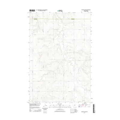
2014 Map of Red Butte NW
USGS Topo · Published 2014About this map
Otter Cr meanders southward through the undulating landscape of Mercer and Oliver counties, forming the primary drainage for this rural stretch of North Dakota. The terrain is defined by a systematic grid of section roads, including 56th Ave SW and 18th St SW, which carve the prairie into agricultural blocks. Near the southern boundary, Rhein Cem serves as a lone cultural landmark and a vital point of interest for genealogists researching early families in the region. To the southwest, a small portion of Brush Cr enters the frame, while the boundary between Mercer Co and Oliver Co runs east-to-west across the northern section of the map. This survey provides a clear view of the land division and natural watercourses before they reach more developed areas to the south.
Find a feature on this map
19 named features on this map. Tap any name to fly to it.
Don’t see what you’re looking for? This feature index may not catch every label — zoom into the map to look around manually.
Map Details
Editions of this 2014 Red Butte NW Map
This is the sole edition of this map. No revisions or reprints were ever made.
Other maps of this area

1954 · McClusky
USGS Topo · 1:250,000

1958 · McClusky
USGS Topo · 1:250,000

1968 · Red Butte
USGS Topo · 1:24,000

1968 · Beulah
USGS Topo · 1:24,000

1968 · Medicine Butte NE
USGS Topo · 1:24,000

1968 · Red Butte NW
USGS Topo · 1:24,000

1968 · Hazen West
USGS Topo · 1:24,000

1968 · Hazen East
USGS Topo · 1:24,000
1972 · Red Butte SW
USGS Topo · 1:24,000
1972 · Medicine Butte SE
USGS Topo · 1:24,000