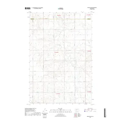
2018 Map of Red Butte NW
USGS Topo · Published 2018About this map
The border of Mercer Co and Oliver Co divides this rural North Dakota landscape, defined by the rolling drainages of Otter Cr and Brush Cr. The terrain is characterized by a high-density grid of section roads, including 12th St SW and 20th St SW, which trace the boundaries of historic townships like T143N R87W. This area remains largely agricultural, with the layout of property lines and access roads reflecting the original Public Land Survey System structure. A significant point of interest for genealogists and local historians is the Rhein Cem located in the southeastern quadrant, representing one of the few named community landmarks in this sparsely populated region. The map preserves the exact alignment of these county line roads and drainage patterns as they existed in the late 2010s.
Find a feature on this map
19 named features on this map. Tap any name to fly to it.
Don’t see what you’re looking for? This feature index may not catch every label — zoom into the map to look around manually.
Map Details
Editions of this 2018 Red Butte NW Map
This is the sole edition of this map. No revisions or reprints were ever made.
Other maps of this area

1954 · McClusky
USGS Topo · 1:250,000

1958 · McClusky
USGS Topo · 1:250,000

1968 · Red Butte
USGS Topo · 1:24,000

1968 · Beulah
USGS Topo · 1:24,000

1968 · Medicine Butte NE
USGS Topo · 1:24,000

1968 · Red Butte NW
USGS Topo · 1:24,000

1968 · Hazen West
USGS Topo · 1:24,000

1968 · Hazen East
USGS Topo · 1:24,000
1972 · Red Butte SW
USGS Topo · 1:24,000
1972 · Medicine Butte SE
USGS Topo · 1:24,000