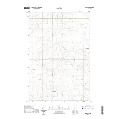
2020 Map of Red Butte NW
USGS Topo · Published 2020About this map
The border of Mercer Co and Oliver Co divides this rural expanse in central North Dakota, where the landscape is defined by the winding course of Otter Cr and Brush Cr. A network of section-line roads, including 12th St SW and 20th St SW, forms a rigid grid across the undulating topography, reflecting the enduring legacy of the Public Land Survey System. In the southeast corner, the presence of the Rhein Cem suggests a focal point for local genealogy, marking a historical site of family and community heritage amidst the open ranchland and fields. The map captures the region's sparse settlement pattern, where infrastructure is primarily dedicated to agricultural access and water drainage across several townships, including t143n r87w.
Find a feature on this map
19 named features on this map. Tap any name to fly to it.
Don’t see what you’re looking for? This feature index may not catch every label — zoom into the map to look around manually.
Map Details
Editions of this 2020 Red Butte NW Map
This is the sole edition of this map. No revisions or reprints were ever made.
Other maps of this area

1954 · McClusky
USGS Topo · 1:250,000

1958 · McClusky
USGS Topo · 1:250,000

1968 · Red Butte
USGS Topo · 1:24,000

1968 · Beulah
USGS Topo · 1:24,000

1968 · Medicine Butte NE
USGS Topo · 1:24,000

1968 · Red Butte NW
USGS Topo · 1:24,000

1968 · Hazen West
USGS Topo · 1:24,000

1968 · Hazen East
USGS Topo · 1:24,000
1972 · Red Butte SW
USGS Topo · 1:24,000
1972 · Medicine Butte SE
USGS Topo · 1:24,000