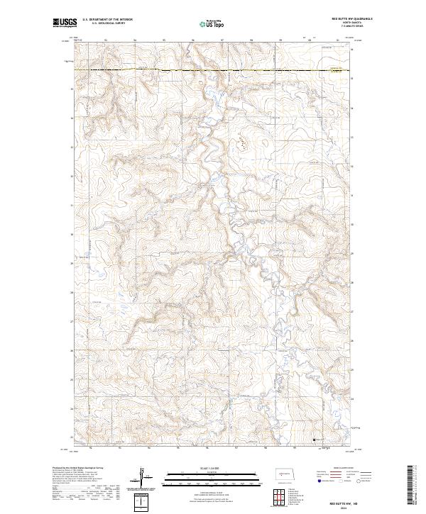
2024 Map of Red Butte NW
USGS Topo · Published 2024About this map
Otter Creek meanders through the heart of this rural landscape, carving a drainage pattern across the high plains of the Mercer and Oliver County border. This modern survey reflects the enduring section-line grid of the western Dakotas, where a network of numbered section roads like 12th St SW and 54th Ave SW facilitate access to vast tracts of agricultural land. The terrain is defined by the subtle rise and fall of the North Dakota prairie, with many contours converging toward the creek basin. A primary site of interest for genealogists is the Rhein Cem, located in the southeastern corner of the map. This small burial ground, situated near the intersection of 20th St SW and Co Rd 20, serves as a critical local landmark for tracing early families who settled this portion of the Missouri Plateau.
Find a feature on this map
19 named features on this map. Tap any name to fly to it.
Don’t see what you’re looking for? This feature index may not catch every label — zoom into the map to look around manually.
Map Details
Editions of this 2024 Red Butte NW Map
This is the sole edition of this map. No revisions or reprints were ever made.
Other maps of this area

1954 · McClusky
USGS Topo · 1:250,000

1958 · McClusky
USGS Topo · 1:250,000

1968 · Red Butte
USGS Topo · 1:24,000

1968 · Beulah
USGS Topo · 1:24,000

1968 · Medicine Butte NE
USGS Topo · 1:24,000

1968 · Red Butte NW
USGS Topo · 1:24,000

1968 · Hazen West
USGS Topo · 1:24,000

1968 · Hazen East
USGS Topo · 1:24,000
1972 · Red Butte SW
USGS Topo · 1:24,000
1972 · Medicine Butte SE
USGS Topo · 1:24,000