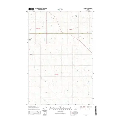
2014 Map of Red Buttes
USGS Topo · Published 2014About this map
The Garfield Co Rosebud Co boundary line divides this eastern Montana landscape, where the high plains transition through a series of dramatic coulees and creek beds. The namesake Red Buttes rise as a prominent landmark in the northern sections, while the drainage network of N Sunday Cr and the W Fork N Sunday Cr dominates the southern terrain. This 2014 survey documents a sparsely settled ranching region defined more by its water sources and topography than by urban development. Local history is etched into the landscape through features like Potter Spring and Rock Spring, alongside evocatively named drainages such as Frozen Dog Coulee and Mackenzie Coulee. Transportation across these remote sections is facilitated by the corridor of MT-59 and rural routes like Angela Rd N, connecting the scattered pastoral holdings across the Rosebud County line.
Find a feature on this map
18 named features on this map. Tap any name to fly to it.
Don’t see what you’re looking for? This feature index may not catch every label — zoom into the map to look around manually.
Map Details
Editions of this 2014 Red Buttes Map
This is the sole edition of this map. No revisions or reprints were ever made.
Other maps of this area

1954 · Forsyth
USGS Topo · 1:250,000

1957 · Forsyth
USGS Topo · 1:250,000

1958 · Forsyth
USGS Topo · 1:250,000

1965 · Rock Springs School
USGS Topo · 1:24,000

1965 · Little Chalk Butte
USGS Topo · 1:24,000

1965 · Clear Water Reservoir
USGS Topo · 1:24,000
1965 · Coleman Coulee
USGS Topo · 1:24,000
1965 · Hillside
USGS Topo · 1:24,000
1965 · Red Buttes
USGS Topo · 1:24,000

1969 · Van Burton Creek
USGS Topo · 1:24,000