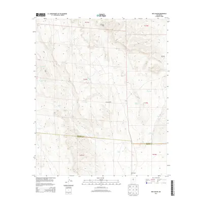
2013 Map of Red Canyon
USGS Topo · Published 2013About this map
Chupadera Mesa dominates the northern elevation of this landscape, where the high ground transitions into the expansive Tularosa Valley. This arid region of Lincoln Co and Socorro Co is defined by a critical network of water management features essential for ranching or military operations in the desert. The presence of the Red Canyon Range Camp suggests the proximity of the White Sands Missile Range or related government activities, while numerous named water sources like School Section Tank, Frenchman Tank, and Little Red Tank provide evidence of land use in a territory where water is the primary currency. Natural features such as Red Canyon Spring and the prominent Flat Top serve as vital landmarks across the basin and range terrain.
Find a feature on this map
23 named features on this map. Tap any name to fly to it.
Don’t see what you’re looking for? This feature index may not catch every label — zoom into the map to look around manually.
Map Details
Editions of this 2013 Red Canyon Map
This is the sole edition of this map. No revisions or reprints were ever made.
Other maps of this area

1918 · Oscura Peak
USGS Topo · 1:125,000

1948 · Broken Back Crater
USGS Topo · 1:62,500

1948 · Bingham
USGS Topo · 1:62,500

1948 · Chihuahua Ranch
USGS Topo · 1:62,500

1948 · Mockingbird Gap
USGS Topo · 1:62,500

1954 · Tularosa
USGS Topo · 1:250,000

1958 · Tularosa
USGS Topo · 1:250,000
1981 · Bull Gap SW
USGS Topo · 1:24,000
1981 · Bull Gap
USGS Topo · 1:24,000
1981 · Broken Back Crater
USGS Topo · 1:24,000