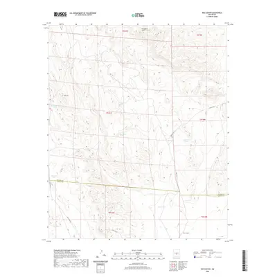
2020 Map of Red Canyon
USGS Topo · Published 2020About this map
Chupadera Mesa dominates the northern elevation of this landscape, where the high desert terrain transitions into the namesake Red Canyon in the south. This 2020 survey documents a vital network of water resources essential for livestock and wildlife in this arid region, including Red Canyon Spring and several named catchment systems such as R C Withers Tanks, Frenchman Tank, and Nolda Tank Number 1. The map also captures the administrative and logistical character of the area, spanning the Socorro and Lincoln County line and showing the access routes managed by the White Sands Missile Range, specifically WSMR P Route 11 and WSMR P Route 9. Distinctive landforms like Flat Top provide natural landmarks in a territory defined by its complex contour lines and drainage patterns.
Find a feature on this map
19 named features on this map. Tap any name to fly to it.
Don’t see what you’re looking for? This feature index may not catch every label — zoom into the map to look around manually.
Map Details
Editions of this 2020 Red Canyon Map
This is the sole edition of this map. No revisions or reprints were ever made.
Other maps of this area

1918 · Oscura Peak
USGS Topo · 1:125,000

1948 · Broken Back Crater
USGS Topo · 1:62,500

1948 · Bingham
USGS Topo · 1:62,500

1948 · Chihuahua Ranch
USGS Topo · 1:62,500

1948 · Mockingbird Gap
USGS Topo · 1:62,500

1954 · Tularosa
USGS Topo · 1:250,000

1958 · Tularosa
USGS Topo · 1:250,000
1981 · Bull Gap SW
USGS Topo · 1:24,000
1981 · Bull Gap
USGS Topo · 1:24,000
1981 · Broken Back Crater
USGS Topo · 1:24,000