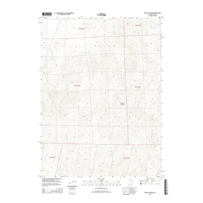
2014 Map of Red Cow Creek
USGS Topo · Published 2014About this map
The Tuscarora Mountains dominate this high-desert landscape in northern Nevada, forming a dramatic backdrop for a complex network of seasonal drainages. This high-altitude drainage basin is defined by the headwaters of the South Fork Owyhee River, which cuts through the northeastern corner of the territory. The map documents a classic Great Basin hydrologic pattern, where numerous creeks including Red Cow Cr, Amazon Cr, and Fourmile Cr descend from the mountain slopes to feed the larger river system. The land is organized by the Public Land Survey System, with boundaries such as t41n r50e dividing the open range. This 2014 survey serves as a detailed study of the remote topography before further modern development, highlighting the isolation and the natural watercourses like Wild Horse Cr and Chino Cr that dictate the character of this interior mountain terrain.
Find a feature on this map
14 named features on this map. Tap any name to fly to it.
Don’t see what you’re looking for? This feature index may not catch every label — zoom into the map to look around manually.
Map Details
Editions of this 2014 Red Cow Creek Map
This is the sole edition of this map. No revisions or reprints were ever made.
Other maps of this area

1955 · McDermitt
USGS Topo · 1:250,000

1956 · Mt. Blitzen
USGS Topo · 1:62,500

1959 · McDermitt
USGS Topo · 1:250,000

1964 · Wilson Reservoir
USGS Topo · 1:62,500

1973 · Little Rock Creek
USGS Topo · 1:24,000

1974 · Soldier Cap
USGS Topo · 1:24,000

1974 · Middle Draw Reservoir
USGS Topo · 1:24,000

1982 · Bull Run Mts
USGS Topo · 1:100,000

1982 · Tuscarora
USGS Topo · 1:100,000
1987 · Toe Jam Mountain
USGS Topo · 1:24,000