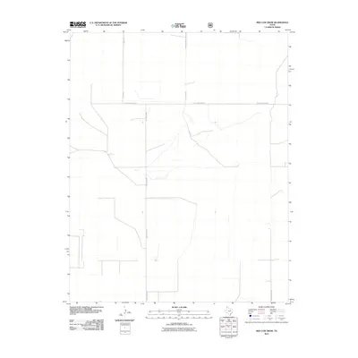
2010 Map of Red Cow Draw
USGS Topo · Published 2010About this map
Andy James Rd and Young Rd bisect this high plains landscape in the northwestern corner of the Texas Panhandle. This 2010 survey reflects a region defined by large-scale land divisions and a sparse network of rural routes, where the naming of roads like E High Lonesome Ln and Lost Camp Rd suggests the isolation and history of the cattle-ranching era. The map reveals the precise section lines and drainage patterns that dictate the movement of both water and cattle across this portion of Dallam County. Researchers of local geography can trace the connectivity provided by Chamberlain Rd and Att Ln as they serve the isolated homesteads and ranching operations of this sparsely populated border region.
Find a feature on this map
6 named features on this map. Tap any name to fly to it.
Don’t see what you’re looking for? This feature index may not catch every label — zoom into the map to look around manually.
Map Details
Editions of this 2010 Red Cow Draw Map
This is the sole edition of this map. No revisions or reprints were ever made.
Other maps of this area

1954 · Dalhart
USGS Topo · 1:250,000

1958 · Dalhart
USGS Topo · 1:250,000

1962 · Dalhart
USGS Topo · 1:250,000

1964 · Stratford 2 SE
USGS Topo · 1:24,000

1964 · Stratford 2 NE
USGS Topo · 1:24,000

1965 · Wilco NE
USGS Topo · 1:24,000

1973 · Stratford 2 NW
USGS Topo · 1:24,000

1973 · Bolin NE
USGS Topo · 1:24,000

1973 · Coldwater East
USGS Topo · 1:24,000
1973 · Pritchard Ranch
USGS Topo · 1:24,000