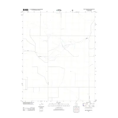
2012 Map of Red Cow Draw
USGS Topo · Published 2012About this map
Red Cow Draw winds through the high plains of Dallam County in this northern Panhandle landscape. The map depicts a territory defined by a sparse, geometric grid of rural roads, including Young Rd and Chamberlain Rd, which connect isolated homesteads and ranching interests. This 2012 survey illustrates the modern intersection of private family lands and the vast drainage network of the draw itself. Family-named thoroughfares such as Andy James Rd and Bowers Ln suggest a lineage of land ownership and local residence in this corner of Texas. The terrain is characterized by the subtle relief of the draw, a vital watercourse in an otherwise arid environment, punctuated by occasional structures and local access points like A T T Ln.
Find a feature on this map
6 named features on this map. Tap any name to fly to it.
Don’t see what you’re looking for? This feature index may not catch every label — zoom into the map to look around manually.
Map Details
Editions of this 2012 Red Cow Draw Map
This is the sole edition of this map. No revisions or reprints were ever made.
Other maps of this area

1954 · Dalhart
USGS Topo · 1:250,000

1958 · Dalhart
USGS Topo · 1:250,000

1962 · Dalhart
USGS Topo · 1:250,000

1964 · Stratford 2 SE
USGS Topo · 1:24,000

1964 · Stratford 2 NE
USGS Topo · 1:24,000

1965 · Wilco NE
USGS Topo · 1:24,000

1973 · Stratford 2 NW
USGS Topo · 1:24,000

1973 · Bolin NE
USGS Topo · 1:24,000

1973 · Coldwater East
USGS Topo · 1:24,000
1973 · Pritchard Ranch
USGS Topo · 1:24,000