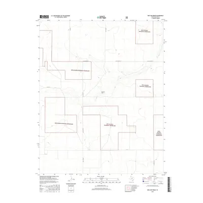
2016 Map of Red Cow Draw
USGS Topo · Published 2016About this map
The Rita Blanca National Grassland dominates this section of the Texas Panhandle, appearing as a fragmented mosaic of protected public lands interspersed with private holdings. This 2016 survey captures the high plains character of Dallam County, where the topography is defined by the subtle drainage of Red Cow Draw. The landscape's human footprint is primarily traced through a sparse grid of named rural corridors, including Andy James Rd and Young Rd, which reflect the vast scale of agricultural and ranching parcels in the region. Local nomenclature like E High Lonesome Ln and Lost Camp Rd hints at the isolation and historical settlement patterns of this corner of the state. Small depressions and wetlands are scattered across the terrain, indicating the vital role of surface water in an otherwise semi-arid environment.
Find a feature on this map
9 named features on this map. Tap any name to fly to it.
Don’t see what you’re looking for? This feature index may not catch every label — zoom into the map to look around manually.
Map Details
Editions of this 2016 Red Cow Draw Map
This is the sole edition of this map. No revisions or reprints were ever made.
Other maps of this area

1954 · Dalhart
USGS Topo · 1:250,000

1958 · Dalhart
USGS Topo · 1:250,000

1962 · Dalhart
USGS Topo · 1:250,000

1964 · Stratford 2 SE
USGS Topo · 1:24,000

1964 · Stratford 2 NE
USGS Topo · 1:24,000

1965 · Wilco NE
USGS Topo · 1:24,000

1973 · Stratford 2 NW
USGS Topo · 1:24,000

1973 · Bolin NE
USGS Topo · 1:24,000

1973 · Coldwater East
USGS Topo · 1:24,000
1973 · Pritchard Ranch
USGS Topo · 1:24,000