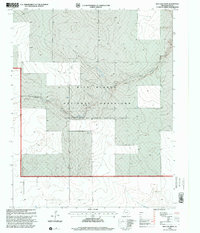
1998 Map of Red Cow Draw
USGS Topo · Published 2001About this map
Rita Blanca National Grassland dominates this panhandle landscape, which was revised by the USDA Forest Service in the late 1990s. The topography is defined by the winding course of Red Cow Draw, a drainage feature that cuts through the High Plains terrain. While much of the area remains open rangeland, the map documents specific points of human activity and industrial infrastructure, including a local Well, a Pipeline in the northwest corner, and a Drill Hole. This edition reflects the management of these public lands under the oversight of the Cibola National Forest, providing a precise record of the grassland's boundaries and topographic contours as they stood at the close of the twentieth century.
Find a feature on this map
5 named features on this map. Tap any name to fly to it.
Don’t see what you’re looking for? This feature index may not catch every label — zoom into the map to look around manually.
Map Details
Editions of this 1998 Red Cow Draw Map
This is the sole edition of this map. No revisions or reprints were ever made.
Other maps of this area

1954 · Dalhart
USGS Topo · 1:250,000

1958 · Dalhart
USGS Topo · 1:250,000

1962 · Dalhart
USGS Topo · 1:250,000

1964 · Stratford 2 SE
USGS Topo · 1:24,000

1964 · Stratford 2 NE
USGS Topo · 1:24,000

1965 · Wilco NE
USGS Topo · 1:24,000

1973 · Stratford 2 NW
USGS Topo · 1:24,000

1973 · Bolin NE
USGS Topo · 1:24,000

1973 · Coldwater East
USGS Topo · 1:24,000
1973 · Pritchard Ranch
USGS Topo · 1:24,000