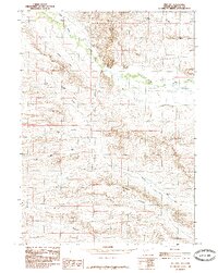
1985 Map of Red Gap
USGS Topo · Published 1985About this map
Red Gap anchors this high-elevation landscape in Lincoln County, Wyoming, where the high desert terrain is defined by an intricate network of seasonal drainages and early irrigation projects. The map documents the vital water infrastructure necessary for cattle ranching and settlement in this arid region, most notably the Anderson Howard Canal and the Red Gap Ditch. These man-made features follow the natural contours of the land, drawing from La Barge Creek to support the surrounding basins.
Find a feature on this map
16 named features on this map. Tap any name to fly to it.
Don’t see what you’re looking for? This feature index may not catch every label — zoom into the map to look around manually.
Map Details
Editions of this 1985 Red Gap Map
This is the sole edition of this map. No revisions or reprints were ever made.
Other maps of this area

1945 · Fort Hill
USGS Topo · 1:62,500

1947 · Fort Hill
USGS Topo · 1:62,500

1955 · Preston
USGS Topo · 1:250,000

1958 · Preston
USGS Topo · 1:250,000

1962 · Preston
USGS Topo · 1:250,000

1968 · Names Hill
USGS Topo · 1:24,000

1968 · Fontenelle Reservoir SW
USGS Topo · 1:24,000

1969 · La Barge
USGS Topo · 1:24,000
1969 · The Hogsback
USGS Topo · 1:24,000
1969 · Lake Mountain
USGS Topo · 1:24,000