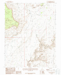
1987 Map of Red House Spring
USGS Topo · Published 1987About this map
Red House Cliffs dominate the landscape of San Juan County in this 1980s-era topographical study, revealing a complex network of canyons and plateaus. The topography is defined by the massive escarpment and the deeply incised drainage systems of Grand Gulch and Steer Gulch. As a provisional map based on 1981 aerial photography, it documents the arid terrain before modern intensive recreation, focusing on natural water sources like Red House Spring and Collins Spring that were vital for early cattle ranching and travel through the Clay Hills. This map serves as an essential reference for understanding the remote physical geography of the Cedar Mesa area, tracing the winding paths of Water Canyon and the tight constrictions of The Narrows. Geographers and historians can examine the land use patterns implied by features such as Steer Pasture Canyon and the high elevation of Polly Mesa.
Find a feature on this map
12 named features on this map. Tap any name to fly to it.
Don’t see what you’re looking for? This feature index may not catch every label — zoom into the map to look around manually.
Map Details
Editions of this 1987 Red House Spring Map
2 editions found
Other maps of this area

1886 · Henry Mountains
USGS Topo · 1:250,000

1892 · Henry Mountains
USGS Topo · 1:250,000

1952 · Mancos Mesa
USGS Topo · 1:62,500

1952 · Natural Bridges
USGS Topo · 1:62,500

1954 · White Canyon 3 SE
USGS Topo · 1:24,000

1954 · White Canyon 4 SE
USGS Topo · 1:24,000

1954 · White Canyon 4 SW
USGS Topo · 1:24,000

1954 · Clay Hills 2 NE
USGS Topo · 1:24,000

1954 · Clay Hills 2 SE
USGS Topo · 1:24,000

1954 · Clay Hills 1 NW
USGS Topo · 1:24,000