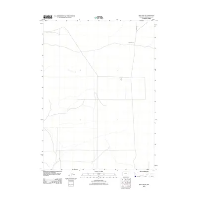
2012 Map of Red Lake SE
USGS Topo · Published 2012About this map
Red Desert Basin occupies this high desert expanse in Sweetwater County, where the landscape is defined more by its internal drainage and dry basins than by permanent settlements. The map illustrates a largely uninhabited portion of Wyoming, characteristic of the remote grazing lands that sustained early twentieth-century livestock operations. One of the few signs of human activity is Blake Sheep Camp, a namesake landmark that reflects the region's historical reliance on seasonal sheep ranching. Infrastructure is minimal, represented primarily by the lone corridor of Tipton N Rd which cuts through the northern section of the quadrangle. This survey documents the vast, open geography of the basin as it remained in the early twenty-first century, preserving the sparse network of tracks and ephemeral water features used by those working the range.
Find a feature on this map
3 named features on this map. Tap any name to fly to it.
Don’t see what you’re looking for? This feature index may not catch every label — zoom into the map to look around manually.
Map Details
Editions of this 2012 Red Lake SE Map
This is the sole edition of this map. No revisions or reprints were ever made.
Other maps of this area

1954 · Rock Springs
USGS Topo · 1:250,000

1958 · Rock Springs
USGS Topo · 1:250,000

1960 · Red Lake
USGS Topo · 1:62,500

1960 · Lost Creek Butte
USGS Topo · 1:62,500

1962 · Rock Springs
USGS Topo · 1:250,000

1970 · Red Desert NW
USGS Topo · 1:24,000

1970 · Tipton
USGS Topo · 1:24,000
1970 · Desert Springs
USGS Topo · 1:24,000
1980 · Red Desert Basin
USGS Topo · 1:100,000
1988 · Red Lake NE
USGS Topo · 1:24,000