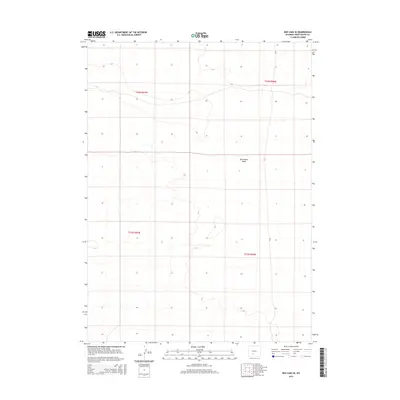
2015 Map of Red Lake SE
USGS Topo · Published 2015About this map
Red Desert Basin occupies this expansive, arid stretch of the High Desert in Sweetwater County. The terrain is defined by subtle elevation changes and interior drainage patterns typical of this endorheic region. The map reflects a landscape primarily dedicated to public land management and energy exploration, structured by the Public Land Survey System lines of t22n r96w, t22n r97w, t21n r96w, and t21n r97w. Transportation is limited to a sparse network of unimproved routes, most notably Cr 67, which provides the primary north-south access through these sagebrush flats. This 2015 survey, produced by the U.S. Geological Survey, captures a moment when the vastness of the basin remained largely undisturbed by major infrastructure, serving as a baseline for the region's environmental and industrial history.
Find a feature on this map
6 named features on this map. Tap any name to fly to it.
Don’t see what you’re looking for? This feature index may not catch every label — zoom into the map to look around manually.
Map Details
Editions of this 2015 Red Lake SE Map
This is the sole edition of this map. No revisions or reprints were ever made.
Other maps of this area

1954 · Rock Springs
USGS Topo · 1:250,000

1958 · Rock Springs
USGS Topo · 1:250,000

1960 · Red Lake
USGS Topo · 1:62,500

1960 · Lost Creek Butte
USGS Topo · 1:62,500

1962 · Rock Springs
USGS Topo · 1:250,000

1970 · Red Desert NW
USGS Topo · 1:24,000

1970 · Tipton
USGS Topo · 1:24,000
1970 · Desert Springs
USGS Topo · 1:24,000
1980 · Red Desert Basin
USGS Topo · 1:100,000
1988 · Red Lake NE
USGS Topo · 1:24,000