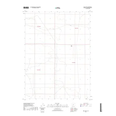
2017 Map of Red Lake SE
USGS Topo · Published 2017About this map
Red Desert Basin dominates this portion of the high Wyoming desert, where the landscape is defined by vast, open topography and subtle elevation shifts. This 2017 survey by the U.S. Geological Survey captures the area in an era of modern resource management and land use, showing the sparse infrastructure required to traverse this interior drainage basin. The primary artery through the region is Co Rd 20, which winds through the northern sections, providing the only significant access point for those navigating these expansive public lands. The map meticulously documents the Public Land Survey System grid across townships t21n r96w and t22n r96w, illustrating the geometric order imposed on a wilderness that remains largely undeveloped. For researchers, it offers a contemporary baseline of the basin's hydrologic and topographic features before further shifts in land use or environmental policy.
Find a feature on this map
6 named features on this map. Tap any name to fly to it.
Don’t see what you’re looking for? This feature index may not catch every label — zoom into the map to look around manually.
Map Details
Editions of this 2017 Red Lake SE Map
This is the sole edition of this map. No revisions or reprints were ever made.
Other maps of this area

1954 · Rock Springs
USGS Topo · 1:250,000

1958 · Rock Springs
USGS Topo · 1:250,000

1960 · Red Lake
USGS Topo · 1:62,500

1960 · Lost Creek Butte
USGS Topo · 1:62,500

1962 · Rock Springs
USGS Topo · 1:250,000

1970 · Red Desert NW
USGS Topo · 1:24,000

1970 · Tipton
USGS Topo · 1:24,000
1970 · Desert Springs
USGS Topo · 1:24,000
1980 · Red Desert Basin
USGS Topo · 1:100,000
1988 · Red Lake NE
USGS Topo · 1:24,000