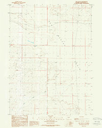
1988 Map of Red Lake SE
USGS Topo · Published 1989About this map
The Red Desert Basin dominates this landscape in southwestern Wyoming, where the terrain is defined by its arid character and energy potential. At the time of this survey, the region shows active resource extraction, evidenced by labels for a Rig, a Gas Well, and a Drill Hole. These industrial markers sit alongside traditional ranching infrastructure like a lone Corral in the southern reaches of the quadrangle.
Find a feature on this map
8 named features on this map. Tap any name to fly to it.
Don’t see what you’re looking for? This feature index may not catch every label — zoom into the map to look around manually.
Map Details
Editions of this 1988 Red Lake SE Map
This is the sole edition of this map. No revisions or reprints were ever made.
Other maps of this area

1954 · Rock Springs
USGS Topo · 1:250,000

1958 · Rock Springs
USGS Topo · 1:250,000

1960 · Red Lake
USGS Topo · 1:62,500

1960 · Lost Creek Butte
USGS Topo · 1:62,500

1962 · Rock Springs
USGS Topo · 1:250,000

1970 · Red Desert NW
USGS Topo · 1:24,000

1970 · Tipton
USGS Topo · 1:24,000
1970 · Desert Springs
USGS Topo · 1:24,000
1980 · Red Desert Basin
USGS Topo · 1:100,000
1988 · Red Lake NE
USGS Topo · 1:24,000