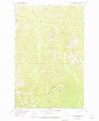
1958 Map of Red Plume Mountain
USGS Topo · Published 1975About this map
Red Plume Mountain and the surrounding high country of the Flathead National Forest dominate this mid-century topographic study. The landscape is defined by a dense network of pack trails and watercourses that supported early forest management and backcountry access, including the Skyland-Morrison Trail and the Twenty-Five Mile Creek Trail. In the northern reaches, the Challenge Cabin sits near the headwaters of Challenge Creek, representing the isolated outposts used by rangers and surveyors in this era. The southern border follows the winding course of the Middle Fork Flathead River, a primary drainage for the many creeks descending from Patrol Ridge and the Puzzle Hills. This map documents a period when these peaks, including Square Mountain and Slippery Bill Mountain, were primarily accessed by foot and pack animal, before modern road expansions altered the wilderness character of the region.
Find a feature on this map
31 named features on this map. Tap any name to fly to it.
Don’t see what you’re looking for? This feature index may not catch every label — zoom into the map to look around manually.
Map Details
Editions of this 1958 Red Plume Mountain Map
Other maps of this area

1913 · Marias Pass
USGS Topo · 1:125,000

1958 · Red Plume Mountain
USGS Topo · 1:24,000

1958 · Gable Peaks
USGS Topo · 1:24,000

1958 · Capitol Mountain
USGS Topo · 1:24,000

1958 · Crescent Cliff
USGS Topo · 1:24,000

1958 · Mount Bradley
USGS Topo · 1:24,000

1958 · Horseshoe Peak
USGS Topo · 1:24,000

1960 · Cut Bank
USGS Topo · 1:250,000

1963 · Cut Bank
USGS Topo · 1:250,000

1964 · Cut Bank
USGS Topo · 1:250,000