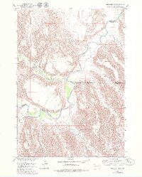
1951 Map of Red Shirt NE
USGS Topo · Published 1979About this map
The Pine Ridge Indian Reservation occupies the southern half of this landscape, its boundary defined by the winding course of the Cheyenne River and survey lines crossing the high plains. This 1951 survey, photorevised in the 1970s, captures the complex drainage systems that carve through the arid terrain. To the north, deep erosional features like Little Corral Draw and Big Corral Draw move toward the river, while the south is dominated by the prominent flat-topped Plenty Star Table. The intricate network of seasonal watercourses, including Battle Creek Canyon and Blindman Creek, illustrates a rugged topography where water has dictated the shape of the land and the limits of the reservation boundary.
Find a feature on this map
16 named features on this map. Tap any name to fly to it.
Don’t see what you’re looking for? This feature index may not catch every label — zoom into the map to look around manually.
Map Details
Editions of this 1951 Red Shirt NE Map
3 editions found
Other maps of this area

1950 · Cuny Table East
USGS Topo · 1:24,000

1951 · Red Shirt
USGS Topo · 1:24,000

1951 · Heutmacher Table
USGS Topo · 1:24,000

1951 · Red Shirt NE
USGS Topo · 1:24,000

1951 · Red Shirt SW
USGS Topo · 1:24,000

1951 · Cuny Table West
USGS Topo · 1:24,000

1953 · Folsom
USGS Topo · 1:24,000

1953 · Caputa SW
USGS Topo · 1:24,000

1954 · Scenic SW
USGS Topo · 1:24,000

1955 · Hot Springs
USGS Topo · 1:250,000