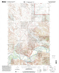
1997 Map of Red Wing Creek
USGS Topo · Published 2001About this map
The Little Missouri River carves a deep path through the southern portion of this landscape, its banks framed by the expansive Little Missouri National Grassland. This 1990s revision reveals a territory where ranching and energy extraction exist side-by-side, characterized by the scattered namesake operations of the Red Wing Oil Field and its accompanying Gas Plant. High on the plains above the river, local life is anchored by the Townhall and the Red Wing Cem situated near the headwaters of Red Wing Creek. For family researchers, the map identifies specific homesteads and properties including the Turnquist Ranch, H Bredwick Ranch, and P Nelson Ranch. The drainage network is clearly defined by several watercourses including Bowline Creek, Bummer Creek, and Cedar Creek, illustrating the complex hydrology of these Badlands-adjacent grasslands.
Find a feature on this map
21 named features on this map. Tap any name to fly to it.
Don’t see what you’re looking for? This feature index may not catch every label — zoom into the map to look around manually.
Map Details
Editions of this 1997 Red Wing Creek Map
This is the sole edition of this map. No revisions or reprints were ever made.
Other maps of this area

1953 · Watford City
USGS Topo · 1:250,000

1957 · Watford City
USGS Topo · 1:250,000

1958 · Sperati Point
USGS Topo · 1:24,000

1958 · Stocke Butte
USGS Topo · 1:24,000

1967 · Watford City
USGS Topo · 1:250,000

1972 · Bear Butte
USGS Topo · 1:24,000

1972 · Moline School
USGS Topo · 1:24,000
1972 · Burning Mine Butte
USGS Topo · 1:24,000

1974 · Wolf Coulee
USGS Topo · 1:24,000
1974 · Ice Box Canyon
USGS Topo · 1:24,000