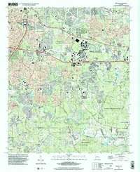
1999 Map of Redan
USGS Topo · Published 2002About this map
Snapfinger Creek and the South River define the winding drainage patterns of this suburbanizing landscape at the turn of the millennium. The map documents a territory in transition where residential growth meets protected natural spaces like Panola Mountain State Park and Davidson-Arabia Mountain Park. Despite the expansion of interstate interchanges, the underlying social fabric is still visible through its high density of community landmarks. From Scarbrough Cross Roads in the south to Glen Haven in the north, the map is dotted with dozens of neighborhood anchors, including Kelleys Chapel, Miller Grove Ch, and New County Line Sch. The convergence of DeKalb, Henry, and Rockdale counties near Klondike highlights a region where historic rural settlements were being integrated into the modern metropolitan network.
Find a feature on this map
61 named features on this map. Tap any name to fly to it.
Don’t see what you’re looking for? This feature index may not catch every label — zoom into the map to look around manually.
Map Details
Editions of this 1999 Redan Map
This is the sole edition of this map. No revisions or reprints were ever made.
Other maps of this area

1888 · Atlanta
USGS Topo · 1:125,000

1890 · Atlanta
USGS Topo · 1:125,000

1892 · Atlanta
USGS Topo · 1:125,000

1895 · Atlanta
USGS Topo · 1:125,000

1953 · Atlanta
USGS Topo · 1:250,000

1954 · Conley
USGS Topo · 1:24,000

1954 · Decatur
USGS Topo · 1:24,000

1954 · Jonesboro
USGS Topo · 1:24,000

1956 · Stone Mountain
USGS Topo · 1:24,000

1956 · Snellville
USGS Topo · 1:24,000