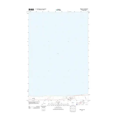
2013 Map of Redby OE N
USGS Topo · Published 2013About this map
Redby sits on the southern edge of the massive Lower Red Lake basin, serving as a primary settlement within the Red Lake Reservation during this 2013 survey. The landscape is defined by its relationship to the water, anchored by the Red Lake Tribal Fish Hatchery and the local Po. Transport in this lakefront community is centered on the corridor provided by MN-1, which parallels the shoreline. Smaller arterial routes like Res Hwy 60, Res Hwy 40, and Res Hwy 41 connect the residential and civic center of Redby to the surrounding woods and smaller water bodies such as Heart Lake. This map provides a contemporary look at the infrastructure of the tribal nation, showing the concentrated development at the water's edge contrasted against the expansive open waters of Red Lake.
Find a feature on this map
11 named features on this map. Tap any name to fly to it.
Don’t see what you’re looking for? This feature index may not catch every label — zoom into the map to look around manually.
Map Details
Editions of this 2013 Redby OE N Map
This is the sole edition of this map. No revisions or reprints were ever made.
Other maps of this area

1919 · Ponemah
USGS Topo · 1:62,500

1943 · Ponemah
USGS Topo · 1:62,500

1954 · Bemidji
USGS Topo · 1:250,000

1954 · Roseau
USGS Topo · 1:250,000

1957 · Roseau
USGS Topo · 1:250,000

1957 · Bemidji
USGS Topo · 1:250,000

1958 · Bemidji
USGS Topo · 1:250,000

1958 · Roseau
USGS Topo · 1:250,000

1972 · Redby
USGS Topo · 1:24,000
1972 · Red Lake
USGS Topo · 1:24,000