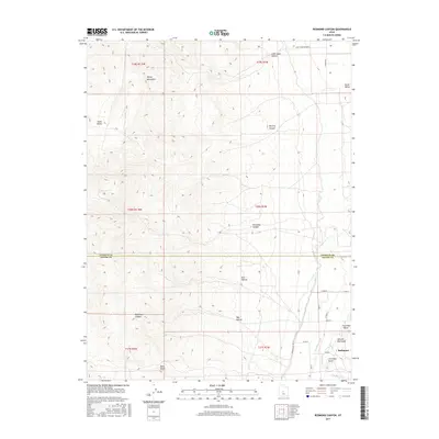
2017 Map of Redmond Canyon
USGS Topo · Published 2017About this map
The town of Redmond sits on the eastern edge of this landscape, situated between the high peaks of the Valley Mountains and the fertile lowlands of the Sevier Valley. This area is defined by a sophisticated water management system vital to Great Basin agriculture, featuring the Piute Canal, the Vermillion Canal, and the descriptively named Little Ditch. These waterways skirt the base of distinct geologic landmarks such as First Red Knoll, Second Red Knoll, and Third Red Knoll. To the west, the terrain rises sharply into a series of drainages including Redmond Canyon, Dastrup Canyon, and Lone Cedar Canyon. The transition from the irrigated valley floor to the high desert canyons illustrates the classic settlement patterns of the region, where communities gathered at the mouths of canyons to harness runoff before it reached the valley basin.
Find a feature on this map
32 named features on this map. Tap any name to fly to it.
Don’t see what you’re looking for? This feature index may not catch every label — zoom into the map to look around manually.
Map Details
Editions of this 2017 Redmond Canyon Map
This is the sole edition of this map. No revisions or reprints were ever made.
Other maps of this area
1885 · Manti
USGS Topo · 1:250,000
1885 · Beaver
USGS Topo · 1:250,000

1885 · Sevier Desert
USGS Topo · 1:250,000
1885 · Fish Lake
USGS Topo · 1:250,000
1895 · Manti
USGS Topo · 1:250,000
1896 · Fish Lake
USGS Topo · 1:250,000

1953 · Richfield
USGS Topo · 1:250,000

1953 · Delta
USGS Topo · 1:250,000
1956 · Salina
USGS Topo · 1:250,000
1956 · Price
USGS Topo · 1:250,000