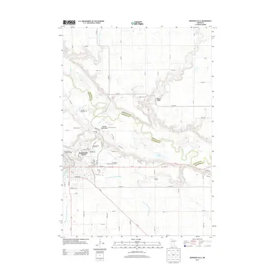
2013 Map of Redwood Falls
USGS Topo · Published 2013About this map
The Minnesota River snakes through the center of this landscape, marking the natural border between Renville Co and Redwood Co. This quadrangle centers on the city of Redwood Falls, where the Redwood River joins the larger waterway. Significant civic and recreational features include the Redwood Falls Municipal Airport, the Johnson Park Fairground, and the Ramsey Park Swayback Bridge. For those researching family history, several burial sites are mapped, including the Beaver Falls Cem, the Valentine Appel Burial Plot, and the Camp Pope Burial Plot. The rural surroundings are defined by a network of drainage systems like County Ditch Number Fiftytwo and County Ditch Number Twentytwo, supporting the agricultural character of settlements such as North Redwood and the Oakleigh Farms area.
Find a feature on this map
75 named features on this map. Tap any name to fly to it.
Don’t see what you’re looking for? This feature index may not catch every label — zoom into the map to look around manually.
Map Details
Editions of this 2013 Redwood Falls Map
This is the sole edition of this map. No revisions or reprints were ever made.
Other maps of this area

1952 · Morton
USGS Topo · 1:62,500

1952 · Redwood Falls
USGS Topo · 1:62,500

1953 · Morgan
USGS Topo · 1:62,500

1953 · New Ulm
USGS Topo · 1:250,000

1957 · New Ulm
USGS Topo · 1:250,000

1958 · New Ulm
USGS Topo · 1:250,000

1967 · New Ulm
USGS Topo · 1:250,000

1967 · Clements
USGS Topo · 1:24,000

1967 · Rowena
USGS Topo · 1:24,000
1982 · Vicksburg
USGS Topo · 1:24,000