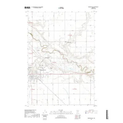
2019 Map of Redwood Falls
USGS Topo · Published 2019About this map
Redwood Falls serves as the hub of this southwestern Minnesota landscape, situated where the Redwood River joins the broader Minnesota River valley. The map reveals a high concentration of memorial sites and burial grounds, such as the Camp Pope Burial Plot, Riverside Cem, and the Appel Burial Plot, which speak to the deep-seated family lineages and early settlement of the county. North across the river, the village of Beaver Falls stands near the Beaver Falls Cem, while North Redwood marks the transition from the river bluffs to the surrounding agricultural plateau.
Find a feature on this map
104 named features on this map. Tap any name to fly to it.
Don’t see what you’re looking for? This feature index may not catch every label — zoom into the map to look around manually.
Map Details
Editions of this 2019 Redwood Falls Map
This is the sole edition of this map. No revisions or reprints were ever made.
Other maps of this area

1952 · Morton
USGS Topo · 1:62,500

1952 · Redwood Falls
USGS Topo · 1:62,500

1953 · Morgan
USGS Topo · 1:62,500

1953 · New Ulm
USGS Topo · 1:250,000

1957 · New Ulm
USGS Topo · 1:250,000

1958 · New Ulm
USGS Topo · 1:250,000

1967 · New Ulm
USGS Topo · 1:250,000

1967 · Clements
USGS Topo · 1:24,000

1967 · Rowena
USGS Topo · 1:24,000
1982 · Vicksburg
USGS Topo · 1:24,000