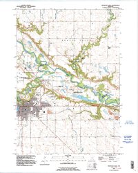
1992 Map of Redwood Falls
USGS Topo · Published 1995About this map
The Minnesota River carves a deep, winding valley through this landscape, marking the boundary between Redwood and Renville Counties. In the early 1990s, Redwood Falls serves as the primary population center, centered around the junction of several streams and featuring significant recreational and civic landmarks like Ramsey Park and the Johnson Park Fairground. To the north, the small settlement of Beaver Falls sits near the mouth of Beaver Creek, where the terrain drops sharply toward the river valley in a series of rapids.
Find a feature on this map
33 named features on this map. Tap any name to fly to it.
Don’t see what you’re looking for? This feature index may not catch every label — zoom into the map to look around manually.
Map Details
Editions of this 1992 Redwood Falls Map
This is the sole edition of this map. No revisions or reprints were ever made.
Other maps of this area

1952 · Morton
USGS Topo · 1:62,500

1952 · Redwood Falls
USGS Topo · 1:62,500

1953 · Morgan
USGS Topo · 1:62,500

1953 · New Ulm
USGS Topo · 1:250,000

1957 · New Ulm
USGS Topo · 1:250,000

1958 · New Ulm
USGS Topo · 1:250,000

1967 · New Ulm
USGS Topo · 1:250,000

1967 · Clements
USGS Topo · 1:24,000

1967 · Rowena
USGS Topo · 1:24,000
1982 · Vicksburg
USGS Topo · 1:24,000