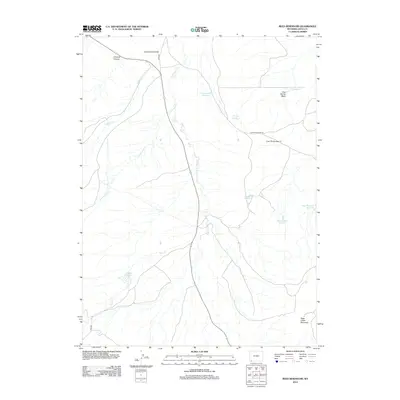
2012 Map of Reed Reservoir
USGS Topo · Published 2012About this map
Reed Reservoir and a network of water management features dominate this high-plains landscape in Uinta County, where the hydrology of Sage Creek and Cottonwood Creek has been carefully channeled. This 2012 survey documents a series of named reservoirs and pits, including the evocatively named Whisky Reservoir, Balsam Root Reservoir, and Clematis Reservoir. The landforms reflect the arid environment, with prominent elevations such as Sage Creek Mountain and the expansive Cottonwood Bench providing topographic contrast. A system of county roads and trails, such as Cedar Mountain Rd and Reed Rd, connects these remote water sources. The map reveals the infrastructure required to sustain agriculture or livestock in the region, tracing the path of drainage through Crooked Canyon and the intermittent flows of Dog Spring Wash.
Find a feature on this map
18 named features on this map. Tap any name to fly to it.
Don’t see what you’re looking for? This feature index may not catch every label — zoom into the map to look around manually.
Map Details
Editions of this 2012 Reed Reservoir Map
This is the sole edition of this map. No revisions or reprints were ever made.
Other maps of this area

1954 · Ogden
USGS Topo · 1:250,000

1958 · Ogden
USGS Topo · 1:250,000

1960 · Ogden
USGS Topo · 1:250,000

1964 · Butcher Knife Draw
USGS Topo · 1:24,000

1964 · Soap Holes Reservoir
USGS Topo · 1:24,000

1964 · Reed Reservoir
USGS Topo · 1:24,000

1964 · Mountain View
USGS Topo · 1:24,000
1964 · Lonetree
USGS Topo · 1:24,000
1964 · Table Mountain
USGS Topo · 1:24,000
1964 · Burntfork
USGS Topo · 1:24,000