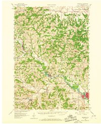
1956 Map of Reedsburg
USGS Topo · Published 1968About this map
The Baraboo River carves a winding path through the heart of the Driftless Area, anchoring a landscape defined by the Chicago and North Western railroad corridor in the mid-1950s. The bustling hub of Reedsburg serves as a focal point, notable for its Teachers College and industrial layout near Hay Creek. Rural life is meticulously documented through dozens of one-room schoolhouses, such as the Cattail Valley Sch and Pleasant Ridge Sch, alongside numerous family and church cemeteries like Pine Eden Cem and Solchenberger Cem. Dramatic topographical landmarks like Castle Rocks and Lighthouse Rock overlook the valleys of Buckwheat Valley and Dutch Hollow, while the Germantown Dam and Lee Lake illustrate the local water management of the era. The presence of an abandoned St Paul Sch highlights the shifting educational landscape of mid-century Wisconsin.
Find a feature on this map
92 named features on this map. Tap any name to fly to it.
Don’t see what you’re looking for? This feature index may not catch every label — zoom into the map to look around manually.
Map Details
Editions of this 1956 Reedsburg Map
3 editions found
Other maps of this area

1901 · Denzer
USGS Topo · 1:62,500

1901 · The Dells
USGS Topo · 1:62,500

1905 · Richland Center
USGS Topo · 1:125,000

1919 · Kendall
USGS Topo · 1:62,500

1921 · Mauston
USGS Topo · 1:62,500

1921 · Kendall
USGS Topo · 1:62,500

1927 · Hillsboro
USGS Topo · 1:62,500

1956 · Reedsburg
USGS Topo · 1:62,500

1957 · Wisconsin Dells
USGS Topo · 1:62,500

1957 · Madison
USGS Topo · 1:250,000