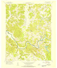
1954 Map of Reedyville
USGS Topo · Published 1955About this map
Green River navigation and rural ridge-top settlement define this mid-century portrait of the Kentucky backcountry at the junction of Butler, Edmonson, and Warren Counties. The river loops through deep bends like Fallover Bend, serving as a vital corridor marked by Lock No 5 and Honakers Ferry. Settlement is concentrated on the high ground of Region Ridge and around crossroads like Reedyville, where community life centered on Bethlehem Ch. The map reveals the early industrial footprint of the region through an Asphalt Quarry near Segal and scattered strip mines. Genealogists can locate numerous family burial grounds, including Threlkel Cem, Cardwell Cem, and Honakers Cem, while schools such as Mt Lebanon Sch represent the era's local education network before further consolidation.
Find a feature on this map
46 named features on this map. Tap any name to fly to it.
Don’t see what you’re looking for? This feature index may not catch every label — zoom into the map to look around manually.
Map Details
Editions of this 1954 Reedyville Map
3 editions found
Other maps of this area

1914 · Little Muddy
USGS Topo · 1:62,500

1922 · Leitchfield
USGS Topo · 1:48,000

1922 · Brownsville
USGS Topo · 1:62,500

1923 · Brownsville
USGS Topo · 1:62,500

1925 · Spring Lick
USGS Topo · 1:62,500

1925 · Leitchfield
USGS Topo · 1:62,500

1953 · Ready
USGS Topo · 1:24,000

1953 · Bee Spring
USGS Topo · 1:24,000

1954 · Evansville
USGS Topo · 1:250,000

1954 · Bowling Green North
USGS Topo · 1:24,000