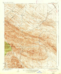
1937 Map of Reef Ridge
USGS Topo · Published 1937About this map
Reef Ridge dominates this mid-1930s landscape at the intersection of Kings, Fresno, and Monterey counties, where high ridges and deep canyons reveal an era of early industrial and ranching activity. The northern section is marked by the Kreyenhagen Hills and the Ernest Kreyenhagen Ranch, while the Kettleman Plain to the east shows early petroleum infrastructure, notably the Union Oil Co Pumping Sta along the Coalinga-Bakersfield Road.
Find a feature on this map
41 named features on this map. Tap any name to fly to it.
Don’t see what you’re looking for? This feature index may not catch every label — zoom into the map to look around manually.
Map Details
Editions of this 1937 Reef Ridge Map
2 editions found
Other maps of this area

1912 · Coalinga
USGS Topo · 1:125,000

1914 · Cholame
USGS Topo · 1:125,000

1915 · Cholame
USGS Topo · 1:125,000

1917 · Cholame
USGS Topo · 1:125,000

1930 · Discovery Well
USGS Topo · 1:31,680

1930 · Canoas Creek
USGS Topo · 1:31,680

1930 · Kettleman Plain
USGS Topo · 1:31,680

1933 · Kettleman Plain
USGS Topo · 1:31,680

1934 · The Dark Hole
USGS Topo · 1:31,680

1934 · Reef Ridge
USGS Topo · 1:31,680