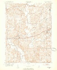
1952 Map of Reelsville
USGS Topo · Published 1954About this map
The Eel River and Big Walnut Creek converge in this mid-century portrait of western Putnam County, where the historic National Road and the Pennsylvania Line railroad facilitate movement through the river valleys. The settlement of Reelsville serves as a local hub, featuring the Reelsville High Sch and nearby Pleasant Gardens. Further east, the village of Manhattan sits along the highway, while large tracts are dedicated to the State Farm.
Find a feature on this map
43 named features on this map. Tap any name to fly to it.
Don’t see what you’re looking for? This feature index may not catch every label — zoom into the map to look around manually.
Map Details
Editions of this 1952 Reelsville Map
2 editions found
Other maps of this area

1908 · Clay City
USGS Topo · 1:48,000

1910 · Clay City
USGS Topo · 1:62,500

1950 · Brazil East
USGS Topo · 1:24,000

1951 · Clinton Falls
USGS Topo · 1:24,000

1951 · Mansfield
USGS Topo · 1:24,000

1952 · Reelsville
USGS Topo · 1:24,000

1953 · Indianapolis
USGS Topo · 1:250,000

1956 · Indianapolis
USGS Topo · 1:250,000

1956 · Cloverdale
USGS Topo · 1:24,000

1956 · Cataract
USGS Topo · 1:24,000