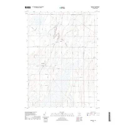
2018 Map of Reeseville
USGS Topo · Published 2018About this map
Reeseville and Lowell serve as the primary hubs in this part of Dodge County, where the agricultural landscape is deeply influenced by the north-south flow of the Beaver Dam River. The village of Lowell sits at a bend in the river, while Reeseville occupies a position to the southwest, connected by a network of rural roads such as Old 16 Rd and Watertown Rd. Significant wetlands and water bodies, including Mud Lake and the winding Shaw Brook, punctuate the drumlin-dominated terrain typical of this region.
Find a feature on this map
61 named features on this map. Tap any name to fly to it.
Don’t see what you’re looking for? This feature index may not catch every label — zoom into the map to look around manually.
Map Details
Editions of this 2018 Reeseville Map
This is the sole edition of this map. No revisions or reprints were ever made.
Other maps of this area

1891 · Waterloo
USGS Topo · 1:62,500

1892 · Watertown
USGS Topo · 1:62,500

1894 · Waterloo
USGS Topo · 1:62,500

1894 · Watertown
USGS Topo · 1:62,500

1910 · Waterloo
USGS Topo · 1:62,500

1955 · Beaver Dam
USGS Topo · 1:62,500

1955 · Horicon
USGS Topo · 1:62,500

1957 · Madison
USGS Topo · 1:250,000
1959 · Richwood
USGS Topo · 1:24,000
1959 · Waterloo
USGS Topo · 1:24,000