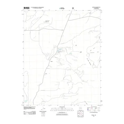
2011 Map of Regina
USGS Topo · Published 2011About this map
Regina serves as the focal point of this Sandoval County landscape, where the high-altitude terrain meets a legacy of resource extraction. The community is defined by its proximity to the San Pedro Mountains and a complex network of seasonal watercourses like Arroyo San Jose and Salado Creek. Evidence of mining activity is scattered throughout the northern and eastern sections, with operations such as the American Mine Number Nine, the Conqueror Arroyo Mine, and the Sta-Tex Venture Mine indicating the historical industrial importance of the region. Water management is central to the area's development, as seen in the Hatch Reservoir Dam and various spring-fed sources like Mora Spring and Hatch Spring. Local roads and trails, including Old Gallina Rd and the San Jose Trl, connect the central settlement to remote landmarks like the Amick Prospect and the historic Regina Cemetery.
Find a feature on this map
38 named features on this map. Tap any name to fly to it.
Don’t see what you’re looking for? This feature index may not catch every label — zoom into the map to look around manually.
Map Details
Editions of this 2011 Regina Map
This is the sole edition of this map. No revisions or reprints were ever made.
Other maps of this area

1889 · Largo
USGS Topo · 1:250,000

1895 · Largo
USGS Topo · 1:250,000

1909 · Gallina
USGS Topo · 1:125,000

1940 · Cuba
USGS Topo · 1:62,500

1943 · Cuba
USGS Topo · 1:62,500

1954 · Aztec
USGS Topo · 1:250,000

1955 · Llaves
USGS Topo · 1:62,500

1958 · Aztec
USGS Topo · 1:250,000

1962 · Aztec
USGS Topo · 1:250,000

1963 · Lindrith
USGS Topo · 1:24,000