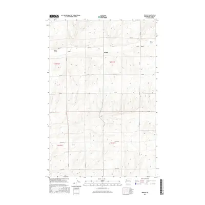
2017 Map of Reiman
USGS Topo · Published 2017About this map
Reiman and Lauer are central nodes in this rural section of the Inland Empire, where the landscape is defined by the sweeping drainage of Rocky Coulee. Located along the border of Washington and Adams counties, the area is characterized by a precise grid of agricultural and access roads that follow the township and range lines of the Public Land Survey System. Named thoroughfares such as Tokio Rd, Griffith Rd, and Seidl Rd connect the scattered settlements and farmsteads, illustrating a land-use pattern focused on dryland farming or ranching. The topographical contours reveal the complex erosional features of the Channeled Scablands, where the coulee floor sits significantly lower than the surrounding basalt plateaus. Jantz remains a notable point of reference on the eastern edge of the quadrangle, linked by Jantz Rd to the broader regional transport network.
Find a feature on this map
19 named features on this map. Tap any name to fly to it.
Don’t see what you’re looking for? This feature index may not catch every label — zoom into the map to look around manually.
Map Details
Editions of this 2017 Reiman Map
This is the sole edition of this map. No revisions or reprints were ever made.
Other maps of this area

1925 · Schrag
USGS Topo · 1:62,500

1953 · Ritzville
USGS Topo · 1:250,000

1959 · Ritzville
USGS Topo · 1:250,000

1965 · Ritzville
USGS Topo · 1:250,000

1967 · Reiman SW
USGS Topo · 1:24,000

1967 · Schoonover
USGS Topo · 1:24,000

1967 · Batum
USGS Topo · 1:24,000

1967 · Reiman
USGS Topo · 1:24,000
1967 · Schrag
USGS Topo · 1:24,000
1967 · Reiman SE
USGS Topo · 1:24,000