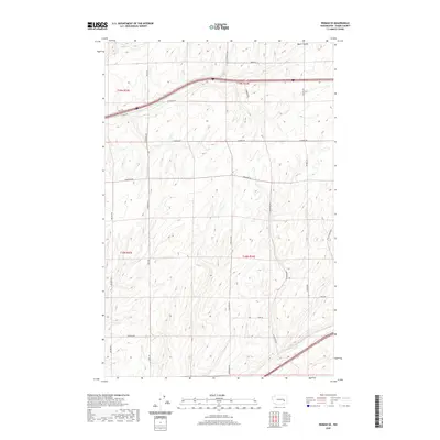
2020 Map of Reiman SE
USGS Topo · Published 2020About this map
Bauer Coulee marks the northern reaches of this Adams County landscape, where the high desert terrain of eastern Washington is defined by a rhythmic pattern of coulees and ridges. This 2020 survey illustrates a region dominated by large-scale agricultural partitions, where the section lines of Townships 18 and 19 North are traced by an extensive network of rural corridors. The map highlights the intersection of modern transit and traditional land use, as Interstate 90 cuts across the northern sections near Schrag Rd and Koch Rd. Local history is embedded in the nomenclature of the many family-named roads that crisscross the quadrangle, including Wahl Rd, Longmeier Rd, and Seivers Rd. In the southeast corner, Highway 395 skirts the edge of the survey near Franz Rd, reflecting the continued importance of these thoroughfares in connecting the isolated farmsteads of the Columbia Plateau.
Find a feature on this map
24 named features on this map. Tap any name to fly to it.
Don’t see what you’re looking for? This feature index may not catch every label — zoom into the map to look around manually.
Map Details
Editions of this 2020 Reiman SE Map
This is the sole edition of this map. No revisions or reprints were ever made.
Other maps of this area

1916 · Connell
USGS Topo · 1:125,000

1918 · Connell
USGS Topo · 1:125,000

1923 · Washtucna
USGS Topo · 1:62,500

1925 · Washtucna
USGS Topo · 1:62,500

1953 · Walla Walla
USGS Topo · 1:250,000

1953 · Ritzville
USGS Topo · 1:250,000

1958 · Walla Walla
USGS Topo · 1:250,000

1959 · Ritzville
USGS Topo · 1:250,000

1965 · Ritzville
USGS Topo · 1:250,000

1967 · Reiman SW
USGS Topo · 1:24,000