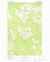
1969 Map of Remmel Mtn.
USGS Topo · Published 1978About this map
Remmel Mtn anchors this section of the High Cascades along the international border between the United States and Canada. Surveyed in the late 1960s, the terrain within the Okanogan National Forest and the Pasayten Wilderness is characterized by high alpine peaks and isolated basins. The presence of the Tungsten Mine near Apex Mountain points to a history of resource extraction in this high-altitude environment, accessible by a network of pack trails such as the Boundary Trail and the Remmel Pack Trail.
Find a feature on this map
56 named features on this map. Tap any name to fly to it.
Don’t see what you’re looking for? This feature index may not catch every label — zoom into the map to look around manually.
Map Details
Editions of this 1969 Remmel Mtn. Map
2 editions found
Other maps of this area

1955 · Concrete
USGS Topo · 1:250,000

1958 · Concrete
USGS Topo · 1:250,000

1962 · Concrete
USGS Topo · 1:250,000

1969 · Mt. Barney
USGS Topo · 1:24,000

1969 · Remmel Mtn.
USGS Topo · 1:24,000

1969 · Billy Goat Mtn
USGS Topo · 1:24,000

1969 · Ashnola Pass
USGS Topo · 1:24,000
1969 · Coleman Peak
USGS Topo · 1:24,000
1969 · Bauerman Ridge
USGS Topo · 1:24,000
2001 · Coleman Peak
USGS Topo · 1:24,000