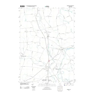
2013 Map of Remsen
USGS Topo · Published 2013About this map
Cincinnati Creek winds through a landscape of historic hamlets and concentrated Welsh heritage in this survey of the Upper Mohawk Valley region. The map documents the spatial arrangement of several long-established communities, including Remsen, Prospect, and Barneveld, alongside numerous family and chapel-associated burial grounds such as Capel Isaf Cem, Capel Ucha Cem, and the distinctive Penn-Y Caerau Cem. These cemetery names reflect the area's strong ethnic settlement patterns that persist in the local geography. To the south, the terrain drops dramatically at Trenton Chasm near Trenton Falls, where West Canada Creek forms a prominent natural boundary. Notable landmarks like the Remsen City Airport and the sprawling Ransoms Tree Farm appear alongside crossroads like Sixty Corners, illustrating the mix of agricultural tradition and early 21st-century infrastructure.
Find a feature on this map
122 named features on this map. Tap any name to fly to it.
Don’t see what you’re looking for? This feature index may not catch every label — zoom into the map to look around manually.
Map Details
Editions of this 2013 Remsen Map
This is the sole edition of this map. No revisions or reprints were ever made.
Other maps of this area

1895 · Oriskany
USGS Topo · 1:62,500

1897 · Remsen
USGS Topo · 1:62,500

1898 · Utica
USGS Topo · 1:62,500

1898 · Oriskany
USGS Topo · 1:62,500

1900 · Utica
USGS Topo · 1:62,500

1900 · Remsen
USGS Topo · 1:62,500

1904 · Boonville
USGS Topo · 1:62,500

1943 · Newport
USGS Topo · 1:24,000
1945 · South Trenton
USGS Topo · 1:31,680
1945 · Newport
USGS Topo · 1:31,680