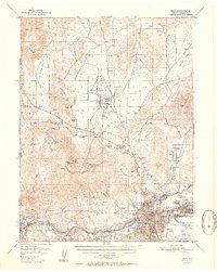
1951 Map of Reno
USGS Topo · Published 1951About this map
The Truckee River defines the southern corridor of this 1951 study, anchoring the growing urban centers of Reno and Sparks. At this time, the development is concentrated along the Southern Pacific and Western Pacific rail lines, while the surrounding desert landscape remains defined by mining and ranching. To the north, the prominence of Peavine Peak overlooks the historic Poe-ville (Site) and the Golden Fleece Mine, signaling the area's transition from 19th-century silver and gold prospecting to a regional transportation hub. Early aviation is represented by Reno Airport and Skyline Airfield, while the industrial footprint is visible at the Gravel Pit and Sewage Disposal sites near the river. Local infrastructure is well-detailed, including the State Hospital, Veterans Hosp, and several cemeteries such as Mtn View Cem, providing a precise look at the mid-century municipal boundaries.
Find a feature on this map
60 named features on this map. Tap any name to fly to it.
Don’t see what you’re looking for? This feature index may not catch every label — zoom into the map to look around manually.
Map Details
Editions of this 1951 Reno Map
2 editions found

Other maps of this area

1890 · Sierraville
USGS Topo · 1:125,000

1891 · Carson
USGS Topo · 1:125,000

1891 · Truckee
USGS Topo · 1:125,000

1891 · Reno
USGS Topo · 1:125,000

1892 · Sierraville
USGS Topo · 1:125,000

1893 · Carson
USGS Topo · 1:125,000

1893 · Truckee
USGS Topo · 1:125,000

1893 · Reno
USGS Topo · 1:125,000

1894 · Sierraville
USGS Topo · 1:125,000

1895 · Truckee
USGS Topo · 1:125,000