
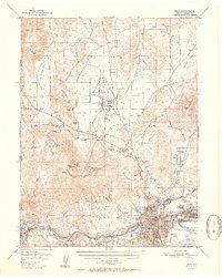
1951 Map of Reno
USGS Topo · Published 1951About this map
Reno and Sparks sit at the center of this mid-century Western landscape, where the Truckee River and the Southern Pacific railroad corridor dictate the path of urban development. Beyond the city grid, the map records a transition from industrial activity to high-desert wilderness, featuring the Golden Fleece Mine and several prospects scattered across the slopes of Peavine Peak. The era's transportation and utility infrastructure is well-defined, from the Orr Ditch and Steamboat Canal providing vital water management to the presence of Skyline Airfield and the Reno Airport. Small, early settlements like Glendale, Lawton, and the historical Poeville (Site) are captured alongside institutional landmarks such as the State Hospital and County Hospital. North of the city, the topography opens into Lemmon Valley and a large Military Reservation, illustrating the expansive land use characteristic of post-war Nevada.
Find a feature on this map
46 named features on this map. Tap any name to fly to it.
Don’t see what you’re looking for? This feature index may not catch every label — zoom into the map to look around manually.
Map Details
Editions of this 1951 Reno Map
2 editions found
Other maps of this area

1890 · Sierraville
USGS Topo · 1:125,000

1891 · Carson
USGS Topo · 1:125,000

1891 · Truckee
USGS Topo · 1:125,000

1891 · Reno
USGS Topo · 1:125,000

1892 · Sierraville
USGS Topo · 1:125,000

1893 · Carson
USGS Topo · 1:125,000

1893 · Truckee
USGS Topo · 1:125,000

1893 · Reno
USGS Topo · 1:125,000

1894 · Sierraville
USGS Topo · 1:125,000

1895 · Truckee
USGS Topo · 1:125,000