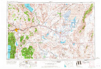
1957 Map of Reno
USGS Topo · Published 1967About this map
Reno and Carson City serve as the primary hubs in this mid-century western Nevada landscape, where the high desert meets the eastern slopes of the Carson Range. The map illustrates a complex water management and natural drainage system, from the deep waters of Lake Tahoe and Pyramid Lake to the terminal evaporation basins of the Carson Sink and Humboldt Sink. Infrastructure from the early 20th century is prominent, including the Lahontan Dam and Derby Dam, which diverted the Truckee River and Carson River to fuel agricultural growth in the Lahontan Reservoir area.
Find a feature on this map
121 named features on this map. Tap any name to fly to it.
Don’t see what you’re looking for? This feature index may not catch every label — zoom into the map to look around manually.
Map Details
Editions of this 1957 Reno Map
5 editions found

Other maps of this area

1886 · Honey Lake
USGS Topo · 1:250,000

1886 · Granite Range
USGS Topo · 1:250,000

1889 · Pyramid Peak
USGS Topo · 1:125,000

1889 · Markleeville
USGS Topo · 1:125,000

1890 · Wadsworth
USGS Topo · 1:125,000

1890 · Sierraville
USGS Topo · 1:125,000

1891 · Honey Lake
USGS Topo · 1:250,000

1891 · Carson
USGS Topo · 1:125,000

1891 · Markleeville
USGS Topo · 1:125,000

1891 · Truckee
USGS Topo · 1:125,000