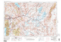
1957 Map of Reno
USGS Topo · Published 1980About this map
Carson City and the burgeoning mountain-side settlements of western Nevada appear during a period of transition in the mid-20th century. The landscape is defined by the high-desert basins of the Carson Sink and the steep eastern slopes of the Sierra Nevada. While Reno and Sparks show significant urban concentration, the surrounding valleys like Washoe Valley and Smith Valley maintain their agricultural character, supported by the intricate irrigation of the Truckee River and Carson River. Military influence is prominent across the salt flats, marked by several U S Naval Target Areas, reflecting the Cold War era's use of the basin for electronic training. This survey provides a look at the extensive transportation network of the Southern Pacific and Western Pacific railroads as they navigate the Virginia Range and connect the remote outposts of Gerlach and Wadsworth.
Find a feature on this map
103 named features on this map. Tap any name to fly to it.
Don’t see what you’re looking for? This feature index may not catch every label — zoom into the map to look around manually.
Map Details
Editions of this 1957 Reno Map
5 editions found

Other maps of this area

1886 · Honey Lake
USGS Topo · 1:250,000

1886 · Granite Range
USGS Topo · 1:250,000

1889 · Pyramid Peak
USGS Topo · 1:125,000

1889 · Markleeville
USGS Topo · 1:125,000

1890 · Wadsworth
USGS Topo · 1:125,000

1890 · Sierraville
USGS Topo · 1:125,000

1891 · Honey Lake
USGS Topo · 1:250,000

1891 · Carson
USGS Topo · 1:125,000

1891 · Markleeville
USGS Topo · 1:125,000

1891 · Truckee
USGS Topo · 1:125,000