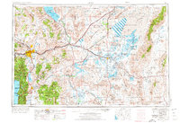
1957 Map of Reno
USGS Topo · Published 1974About this map
Pyramid Lake and the expanse of the Carson Sink dominate this mid-century portrait of western Nevada, illustrating a landscape defined by terminal lakes and alkaline basins. The map captures the regional transition from the urban centers of Reno, Sparks, and Carson City to the wide-open military and agricultural zones to the east. Of particular interest to historians are the remnants of the Virginia & Truckee RR and the proximity of the Fort Churchill Historic State Monument to the Carson River. The geography reveals a complex water management system, from the Truckee Canal feeding the Lahontan Reservoir to the numerous wildlife refuges like Stillwater National Wildlife Refuge that depend on these flows. In the eastern reaches, the vast U S Naval Baker 16 Target Area and other military ranges show the mid-century's strategic use of the desert floor.
Find a feature on this map
206 named features on this map. Tap any name to fly to it.
Don’t see what you’re looking for? This feature index may not catch every label — zoom into the map to look around manually.
Map Details
Editions of this 1957 Reno Map
5 editions found

Other maps of this area

1886 · Honey Lake
USGS Topo · 1:250,000

1886 · Granite Range
USGS Topo · 1:250,000

1889 · Pyramid Peak
USGS Topo · 1:125,000

1889 · Markleeville
USGS Topo · 1:125,000

1890 · Wadsworth
USGS Topo · 1:125,000

1890 · Sierraville
USGS Topo · 1:125,000

1891 · Honey Lake
USGS Topo · 1:250,000

1891 · Carson
USGS Topo · 1:125,000

1891 · Markleeville
USGS Topo · 1:125,000

1891 · Truckee
USGS Topo · 1:125,000