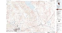
1980 Map of Reno
USGS Topo · Published 1980About this map
Pyramid Lake and its surrounding desert basins dominate this 1980 survey, illustrating the convergence of high-desert water resources and urban expansion. The urban corridor of Reno and Sparks is shown in detail, showing the importance of the Truckee River and the dual presence of the Southern Pacific and Western Pacific railroads. The map highlights the vast Pyramid Lake Indian Reservation, containing landmark features like The Pyramid and Anaho Island.
Find a feature on this map
110 named features on this map. Tap any name to fly to it.
Don’t see what you’re looking for? This feature index may not catch every label — zoom into the map to look around manually.
Map Details
Editions of this 1980 Reno Map
3 editions found
Other maps of this area

1886 · Honey Lake
USGS Topo · 1:250,000

1886 · Granite Range
USGS Topo · 1:250,000

1890 · Wadsworth
USGS Topo · 1:125,000

1890 · Sierraville
USGS Topo · 1:125,000

1891 · Honey Lake
USGS Topo · 1:250,000

1891 · Carson
USGS Topo · 1:125,000

1891 · Truckee
USGS Topo · 1:125,000

1891 · Wabuska
USGS Topo · 1:125,000

1891 · Reno
USGS Topo · 1:125,000

1892 · Wadsworth
USGS Topo · 1:125,000