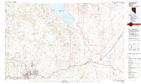
1980 Map of Reno
USGS Topo · Published 1980About this map
Pyramid Lake and the Pyramid Lake Indian Reservation dominate the northern reach of this 1980 survey, where the high desert terrain meets the water. The corridor following the Truckee River reveals the heavy infrastructure of the late 20th century, linking the urban centers of Reno and Sparks with outlying settlements like Vista and Mustang. This industrial and transit backbone is defined by the Southern Pacific and Western Pacific rail lines, which parallel the river through the Virginia Range.
Find a feature on this map
76 named features on this map. Tap any name to fly to it.
Don’t see what you’re looking for? This feature index may not catch every label — zoom into the map to look around manually.
Map Details
Editions of this 1980 Reno Map
3 editions found
Other maps of this area

1886 · Honey Lake
USGS Topo · 1:250,000

1886 · Granite Range
USGS Topo · 1:250,000

1890 · Wadsworth
USGS Topo · 1:125,000

1890 · Sierraville
USGS Topo · 1:125,000

1891 · Honey Lake
USGS Topo · 1:250,000

1891 · Carson
USGS Topo · 1:125,000

1891 · Truckee
USGS Topo · 1:125,000

1891 · Wabuska
USGS Topo · 1:125,000

1891 · Reno
USGS Topo · 1:125,000

1892 · Wadsworth
USGS Topo · 1:125,000