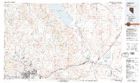
1980 Map of Reno
USGS Topo · Published 1980About this map
Pyramid Lake and its surrounding desert basins dominate this topographic survey, revealing the complex water and transport systems of western Nevada. The Truckee River carves a vital path through the mountains, serving as the corridor for the Southern Pacific railroad and major highways that link Reno and Sparks to the eastern desert flats. This era shows significant suburban development in Sun Valley and Lemmon Valley, contrasted against the vast lands of the Pyramid Lake Indian Reservation and the industrial activity at sites like the Celatom Mine.
Find a feature on this map
101 named features on this map. Tap any name to fly to it.
Don’t see what you’re looking for? This feature index may not catch every label — zoom into the map to look around manually.
Map Details
Editions of this 1980 Reno Map
3 editions found
Other maps of this area

1886 · Honey Lake
USGS Topo · 1:250,000

1886 · Granite Range
USGS Topo · 1:250,000

1890 · Wadsworth
USGS Topo · 1:125,000

1890 · Sierraville
USGS Topo · 1:125,000

1891 · Honey Lake
USGS Topo · 1:250,000

1891 · Carson
USGS Topo · 1:125,000

1891 · Truckee
USGS Topo · 1:125,000

1891 · Wabuska
USGS Topo · 1:125,000

1891 · Reno
USGS Topo · 1:125,000

1892 · Wadsworth
USGS Topo · 1:125,000